
Mount Kilimanjaro Lemosho Route – 6, 7 or 8 DaysScenic Camping Route
Mountain Trek (Camping Route)
Lemosho Glades • Shira Plateau • Barranco • Karanga • Barafu • Mweka • Uhuru Peak
Description
Climb Kilimanjaro via the beautiful Lemosho Route. Starting on the western slopes, Lemosho traverses the Shira Plateau with expansive views and offers excellent acclimatization through climb-high, sleep-low profiles. The recommended 7–8 day plans improve comfort and summit success.
Choose 6, 7 or 8 days: 6 days is the quicker ascent; 7–8 days add acclimatization across the Shira Plateau or at Karanga for improved success. Fully supported with experienced mountain guides, porters, meals, park fees and transfers.
Trek Highlights
Camping route: Lemosho Glades, Shira, Barranco, Karanga, Barafu; Mweka exit
Panoramic traverse across Shira Plateau with excellent acclimatization
Optional acclimatization day at Karanga (7–8 day plans)
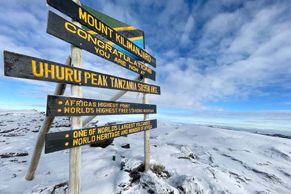
Summit attempt from Barafu to Uhuru Peak (5,895m)
Experienced mountain guides, porters and meals included
Day-by-Day Lemosho Route Itinerary
Day 1: Lemosho Gate → Mti Mkubwa (Big Tree) Camp
3–4 hours • 6–8 km • 2,100 m → 2,780 m
The Lemosho Route is widely regarded as the most scenic and best-acclimatised approach to Uhuru Peak, approaching Kilimanjaro from the west through pristine wilderness accessed by very few trekkers each day. The journey begins with a transfer from Moshi or Arusha to the remote Lemosho Gate, a drive that already rewards with sweeping views of Kilimanjaro’s full western face. After registration and team introductions, the trail enters an extraordinary montane forest that remains largely undisturbed by commercial traffic — giant African camphorwood trees, wild olive, and Podocarpus mirkei form a dense multi-storey canopy alive with hornbills, Hartlaub’s turaco, and olive ibis. Cape buffalo and elephant are occasionally encountered in this section of the forest; your guide is trained in safe wildlife protocol. The trail is gentle and the elevation gain modest, making this a perfect warm-up stage. Mti Mkubwa (Swahili for “Big Tree”) Camp at 2,780 m is a beautiful forest clearing camp named for the enormous, ancient trees that surround it. Your porter team has camp fully prepared on arrival; hot dinner in the mess tent as the forest settles into its nocturnal chorus.
Accommodation: Mti Mkubwa Camp (2,780 m) | Meals: Breakfast, Lunch & Dinner
Day 2: Mti Mkubwa Camp → Shira 1 Camp
4–6 hours • 8 km • 2,780 m → 3,500 m
Leaving the forest, the trail climbs steadily through the heather-moorland transition zone before ascending a long ridge onto the western edge of the ancient Shira Plateau. The Shira Plateau is the remnant caldera of Kilimanjaro’s oldest and most heavily eroded volcanic cone, collapsed hundreds of thousands of years ago and now a vast, open lava field at approximately 3,500–3,840 metres. The sense of space on the plateau is dramatic — flat, wind-swept grassland stretching in every direction with Kibo’s massive summit cone rising to the east and the Kenyan plains visible to the north. Giant lobelias and senecios punctuate the otherwise sparse plateau vegetation, and the air temperature drops noticeably as you gain altitude. Shira 1 Camp (3,500 m) sits at the western edge of the plateau and is a quieter, more exposed site than Shira 2, giving trekkers on the longer Lemosho itinerary an extra night of gentle acclimatization before continuing deeper onto the plateau. Your porter team erects camp and serves hot meals as the evening brings a spectacular high-altitude sunset.
Accommodation: Shira 1 Camp (3,500 m) | Meals: Breakfast, Lunch & Dinner
Day 3: Shira 1 Camp → Shira 2 Camp
3–4 hours • 6 km • 3,500 m → 3,840 m
Today is a shorter, gentler traverse across the Shira Plateau from Shira 1 to Shira 2 — a stage unique to the longest Lemosho itinerary and one that contributes significantly to acclimatization before the critical Lava Tower day. The trail crosses the open plateau with Kibo filling the eastern horizon and the vast, cloud-filled plains of western Tanzania visible below. Optional acclimatization side hikes to the Shira Cathedral, a dramatic volcanic tower at the plateau’s northern edge, or toward the Shira Needle can be arranged with your guide if energy and conditions allow. The plateau’s sparse vegetation — tussock grasses, helichrysum everlastings, and cushion plants — is deceptively rich with high-altitude specialist species adapted to extreme temperature swings of up to 30°C between midday sun and nighttime frost. Shira 2 Camp (3,840 m) is a well-established site near a seasonal stream with dramatic views of Kibo’s southern face and the full sweep of the Southern Glaciers. This is the last camp on the Shira Plateau before the route turns east toward Lava Tower and the descent into the Southern Circuit.
Accommodation: Shira 2 Camp (3,840 m) | Meals: Breakfast, Lunch & Dinner
Day 4: Shira 2 Camp → Barranco Camp via Lava Tower
6–8 hours • 10 km • 3,840 m → 4,600 m → 3,960 m
The most important acclimatization day on the Lemosho Route, today’s ‘climb high, sleep low’ stage takes you to the dramatic Lava Tower at 4,600 metres before descending to camp at 3,960 metres. Departing Shira 2, the trail climbs steadily eastward across increasingly barren volcanic terrain toward the Arrow Glacier Junction and then to the base of the Lava Tower, a spectacular free-standing volcanic plug that protrudes 300 metres from the surrounding desert landscape. Reaching 4,600 metres for several hours during the day stimulates vital physiological acclimatization responses, increasing red blood cell production and improving the body’s oxygen efficiency in preparation for the summit push. The high-altitude desert around Lava Tower is completely devoid of vegetation, replaced by fractured lava, pumice, and the distant glitter of the Southern Glaciers above. The descent from Lava Tower into the Barranco Valley is a vivid journey through geological drama — into a deep canyon with towering volcanic walls and giant senecios that can reach four to five metres in height. Barranco Camp (3,960 m) is one of the most spectacular campsites on Kilimanjaro, sheltered within the valley with the Great Barranco Wall rising directly above.
Accommodation: Barranco Camp (3,960 m) | Meals: Breakfast, Lunch & Dinner
Day 5: Barranco Camp → Karanga Camp
4–5 hours • 5 km • 3,960 m → 4,035 m
The day begins with the famous and exhilarating Barranco Wall scramble — a 300-metre ascent up exposed volcanic rock that is the most technically engaging section of the Southern Circuit. The wall appears forbidding from below but proves accessible for trekkers of all levels, with excellent handholds, confident guides, and a steady stream of fellow climbers making the ascent a social and rewarding event. The views from the top of the wall are extraordinary — Barranco Camp small below, Kibo massive and close above, and the full Southern Ice Field visible on the crater rim. From the top of the wall, the trail traverses a series of rolling ridges and shallow valleys across the Southern Circuit, offering continuous views of Kibo’s southern face and the retreating glaciers that have shrunk dramatically over the last century. The Karanga Valley, with its seasonal glacial meltwater stream, marks the midpoint of the traverse. Karanga Camp (4,035 m) sits on a ridge above the valley in a relatively sheltered position with good sunset views of Kibo. The extra night here, compared to routes that continue directly to Barafu, is a valuable additional acclimatization stage for trekkers on the 7 and 8-day Lemosho options.
Accommodation: Karanga Camp (4,035 m) | Meals: Breakfast, Lunch & Dinner
Day 6: Karanga Camp → Barafu Camp
3–4 hours • 4 km • 4,035 m → 4,640 m
A shorter, focused stage from Karanga to Barafu, the main high camp for the Machame and Lemosho Routes. The trail climbs across the rocky southern face of Kibo through an entirely barren landscape of volcanic scree, lava rubble, and loose pumice. With every hundred metres of elevation gain, the thinning air becomes more perceptible and the effort required per step increases measurably. Arriving at Barafu Camp (4,640 m) by early afternoon provides critical extra rest hours before the midnight start. Barafu — meaning ‘ice’ in Kiswahili — sits on a narrow, windswept ridge with near-vertical drops on both sides, and on clear afternoons the views extend south to Mount Meru rising above the clouds and north to the Kenyan border. Your guide delivers a detailed summit briefing, covering the route, clothing requirements, pacing strategy, and turn-back criteria, before sending you to bed by 6:00 pm with strict instructions to rest. Hot soup and a simple dinner are served early. The hours between dinner and the midnight start feel both very short and very long.
Accommodation: Barafu Camp (4,640 m) | Meals: Breakfast, Lunch & Dinner
Day 7: Summit Night — Uhuru Peak (5,895 m) → Mweka Camp
12–16 hours • 4,640 m → 5,895 m → 3,100 m • The hardest day
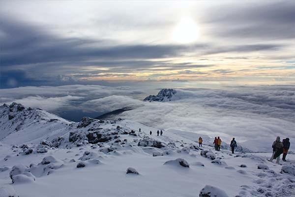
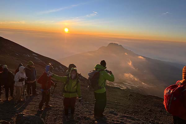
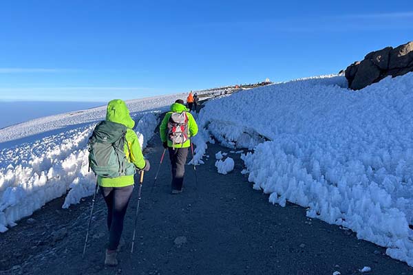
The summit push launches at midnight or 1:00 am, beginning in near-darkness with headlamps, full winter layering, and the sound of cramponing boots on loose volcanic rock. The trail ascends steeply through the barren alpine desert, switchbacking relentlessly toward the crater rim as temperature falls and the available oxygen diminishes to approximately 50% of sea level. The Lemosho Route’s exceptional acclimatization profile — seven or eight days of careful, gradual ascent — now pays its dividend: trekkers are physiologically better prepared for the summit push than those on shorter routes, and the Lemosho Route consistently records the highest summit success rates of any path to Uhuru Peak. The horizon ahead slowly separates into sky and earth as dawn approaches, and reaching Stella Point (5,739 m) at crater rim level at first light is an experience of stunning, almost overwhelming beauty. The final 45-minute traverse of the crater rim to Uhuru Peak (5,895 m) is walked in full daylight, with the Southern Ice Field towering to the left and the vast African plains stretching to every horizon below. After celebrations, photographs, and a moment of profound stillness at the summit, the descent begins via the Mweka Route, arriving at Mweka Camp (3,100 m) by late afternoon.
Accommodation: Mweka Camp (3,100 m) | Meals: Breakfast, Lunch & Dinner
Day 7/8: Mweka Camp → Mweka Gate → Transfer
3–4 hours • 10 km • 3,100 m → 1,640 m
The final morning brings a celebratory breakfast and the last descent through Kilimanjaro’s montane rainforest to the Mweka Gate. The lower forest is warm, green, and rich with birdsong — a vivid contrast to the barren altitude you have spent the past week in — and the improved oxygen at lower elevation makes each step feel noticeably lighter. At the Mweka Gate (1,640 m), the KINAPA sign-out and certificate ceremony completes the official record of your ascent. The coveted gold Uhuru Peak certificate is presented to those who stood on the summit, and the green certificate to those who reached Gillman’s Point or Stella Point. The farewell ceremony with your porter and guide team — singing, photographs, the deeply appreciated distribution of tips, and heartfelt expressions of pride in what you achieved together — is a moment that remains vivid long after the physical memories of the climb have faded. Transfer to Moshi or Arusha to complete what is universally recognised as one of the world’s great trekking achievements.
Accommodation: N/A — Return to Moshi / Arusha | Meals: Breakfast & Lunch
Includes & Excludes
Kilimanjaro park fees and camping fees
Certified mountain guide, porters and cook
All meals on the mountain (breakfast, lunch, dinner)
Drinking water during the trek
Transfers: Moshi/Arusha ↆLemosho Gate / Mweka Gate
Rescue fees and government taxes
International flights and Tanzania visa
Travel & medical insurance (mandatory)
Personal trekking gear (boots, clothing, sleeping bag)
Hotels before/after trek and meals in town
Tips for crew (guide, porters, cook)
Optional personal snacks and alcoholic beverages
Frequently Asked Questions
The best seasons are June–October and January–March for stable weather and clearer skies. Expect cold nights near Barafu and potential rains in April–May and November. We'll advise the ideal window based on your dates.
Lemosho is a camping route. We provide four-season tents, sleeping mattresses and hot meals prepared by our mountain crew. There are no huts along the Lemosho trail. Bring a warm sleeping bag and personal toiletries.
Lemosho is considered moderate with excellent acclimatization on 7–8 day itineraries. The summit day is long. Suitable for fit trekkers; regular training (hikes, cardio) and proper gear are important.
Essential items: sturdy trekking boots, layered clothing, waterproof jacket/pants, warm hat and gloves, headlamp with spare batteries, trekking poles, SPF sunscreen, 3L hydration system, personal meds, and a 4-season sleeping bag. A detailed packing list will be provided.
We generally recommend Kilimanjaro treks for ages 12+ with good fitness. Altitude affects everyone differently; minors must trek with a responsible adult and follow guide advice. Contact us to assess suitability for your family and choose the right plan.
Kilimanjaro Trek Details
Route
Lemosho Route (Western Approach)
Duration
5 or 6 Days
Huts
Lemosho Glades • Shira • Barranco • Karanga • Barafu • Mweka
Max Altitude
Uhuru Peak (5,895 m)
Accommodation
Mountain huts (shared dorms)
Start & Exit
Marangu Gate
Best For
First-time trekkers seeking hut comfort
Trek Price
$Upon Request / Per Person
Price depends on route choice, group size & season
Why Book With Us
Expertise and Experience
Tailored Services
Comprehensive Planning
Client Satisfaction
24/7 Support
Contact Details
Mr. Yamat
Tour Operator
Call Us : +255 686 241 980
Email : info@safarismate.com
Related Kilimanjaro Routes
Price Upon Request
Price Upon Request
Price Upon Request
Price Upon Request